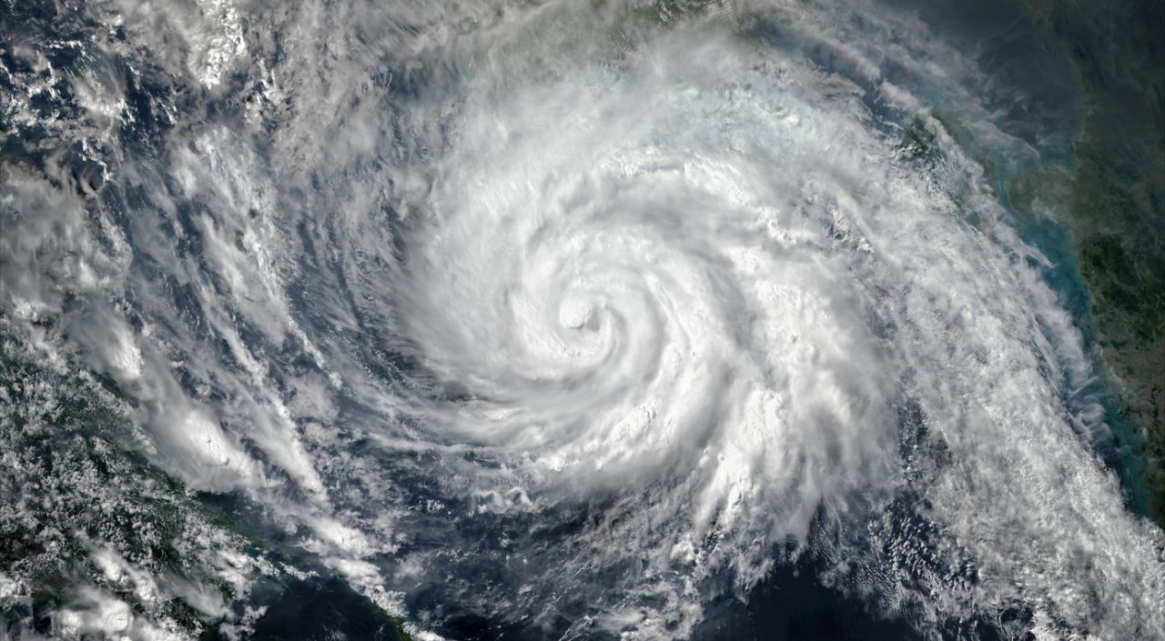
- Бърза ескалация: Исаяс се превърна в първия ураган за сезона в Атлантика и продължава бързо да набира мощ, приближавайки северното крайбрежие на Мексиканския залив.
- Мащабна мобилизация: Флорида, Алабама и Джорджия обявиха извънредно положение, а армията и Националната гвардия са в пълна готовност.
- Парализиран транспорт и енергетика: Летища спират работа, влаковите линии са блокирани, а гиганти като Shell и Chevron евакуират работниците си от петролните платформи.
САЩ се подготвят за първия си опустошителен сблъсък с тропическа стихия за сезона. Ураганът „Исаяс“ (Isaias) бързо придоби мощ в океана и се придвижва към северното крайбрежие на Мексиканския залив, като се очаква за кратко да достигне страховитата категория 3 („голям ураган“), преди да връхлети сушата.
Според метеоролозите сухопътните райони са застрашени от воден капан: очакват се щормови приливи с височина до 2,1 метра (7 фута), до 380 л/кв.м (15 инча) дъжд и изненадващи торнада, които ще възникват с минимално предварително предупреждение.
Разширяващо се око и нощна капана от торнада
Въпреки че се очаква ураганът леко да отслабне непосредствено преди да връхлети върху сушата, физиката на стихията крие допълнителна опасност. Навлизането на атмосферно срязване на вятъра ще дебалансира бурята, но това всъщност ще разшири радиуса на разрушителните ѝ ветрове. Подобно на фигурист, който разперва ръце, за да запази равновесие, Исаяс ще разпростре ветровете си на много по-голяма площ навътре в сушата. Пориви от 50 до 80 км/ч се очакват чак в северните части на Алабама, Джорджия и Мисисипи, което гарантирано ще доведе до съборени дървета и прекъсвания на електрозахранването.
Hurricane Isaias is now a Category 1 storm with maximum sustained winds of 85 mph and a central pressure of 975 mb. Isaias is forecast to strengthen to Category 2 intensity (around 105–110 mph) by early Friday before making landfall late Friday or early Saturday along the northern Gulf Coast Gulf oil and gas production has been partially shut in, Florida has issued some mandatory evacuations in the panhandle, and Alabama has a state of emergency with voluntary evacuation recommendations for non-residents. #Hurricane #Isaias
— Breaking X (@BreakingXAlerts) October 8, 2026
Най-големият кошмар за синоптиците обаче са нощните торнада. Очаква се бурята да генерира смерчове през нощта. Изследванията показват, че нощните торнада са почти двойно по-фатални, тъй като хората спят и не могат да видят приближаващата опасност или да чуят сирените. Властите призоваха всички жители в застрашените зони да държат силата на звука на извънредните си известия на телефоните си на максимум.
Извънредно положение и блокиран живот
Няколко американски щата предприеха светкавични мерки:
Флорида: Губернаторът Рон Десантис обяви извънредно положение за 25 окръга в северозападната част на щата (Panhandle) и региона Биг Бенд. Обявени са задължителни евакуации за най-уязвимите зони, а редица летища превантивно затвориха врати.
Алабама: Губернаторът Кей Айви въведе извънредно положение в 40 окръга и разпореди държавните институции да спрат работа. Железопътният гигант Amtrak изцяло спря движението на влаковете по линията Mardi Gras между Ню Орлиънс и Мобил най-малко до неделя.
Джорджия: Губернаторът Брайън Кемп обяви извънредно положение за целия щат и мобилизира 500 бойци от Националната гвардия за бързо реагиране.
Петролните гиганти Chevron и Shell също започнаха евакуация на персонала си от офшорните платформи в Мексиканския залив и временно спряха добива на суровина.
BULLETIN Hurricane Isaias Intermediate Advisory Number 9A NWS National Hurricane Center Miami FL AL092026 700 PM CDT Thu Oct 08 2026 ...PREPARATIONS TO PROTECT LIFE AND PROPERTY FROM STORM SURGE AND DAMAGING WINDS SHOULD BE RUSHED TO COMPLETION IN THE WARNING AREA... SUMMARY OF 700 PM CDT...0000 UTC...INFORMATION ---------------------------------------------- LOCATION...24.9N 88.8W ABOUT 255 MI...410 KM NNE OF PROGRESO MEXICO ABOUT 290 MI...470 KM S OF THE MOUTH OF THE MISSISSIPPI RIVER MAXIMUM SUSTAINED WINDS...100 MPH...155 KM/H PRESENT MOVEMENT...NE OR 45 DEGREES AT 13 MPH...20 KM/H MINIMUM CENTRAL PRESSURE...974 MB...28.77 INCHES WATCHES AND WARNINGS -------------------- CHANGES WITH THIS ADVISORY: None. SUMMARY OF WATCHES AND WARNINGS IN EFFECT: A Storm Surge Warning is in effect for... * Mouth of the Mississippi River to the Suwannee River A Hurricane Warning is in effect for... * Ocean Springs, MS to the Bay/Gulf County Line, FL A Tropical Storm Warning is in effect for... * Jefferson/Plaquemines Parish Line, LA to west of Ocean Springs, MS * East of Bay/Gulf County Line to Aucilla River, FL A Storm Surge Watch is in effect for... * Suwannee River to Yankeetown, FL A Storm Surge Warning means there is a danger of life-threatening inundation, from rising water moving inland from the coastline, during the next 36 hours in the indicated locations. For a depiction of areas at risk, please see the National Weather Service Storm Surge Watch/Warning Graphic, available at https://t.co/PoajaeXEJG. This is a life-threatening situation. Persons located within these areas should take all necessary actions to protect life and property from rising water and the potential for other dangerous conditions. Promptly follow evacuation and other instructions from local officials. A Hurricane Warning means that hurricane conditions are expected somewhere within the warning area, in this case within 24 to 36 hours. Preparations to protect life and property should be rushed to completion. A Tropical Storm Warning means that tropical storm conditions are expected somewhere within the warning area within 36 hours. A Storm Surge Watch means there is a possibility of life- threatening inundation, from rising water moving inland from the coastline, in the indicated locations during the next 48 hours. For a depiction of areas at risk, please see the National Weather Service Storm Surge Watch/Warning Graphic, available at https://t.co/PoajaeXEJG. For storm information specific to your area, including possible inland watches and warnings, please monitor products issued by your local National Weather Service forecast office. DISCUSSION AND OUTLOOK ---------------------- At 700 PM CDT (0000 UTC), the center of Hurricane Isaias was located near latitude 24.9 North, longitude 88.8 West. Isaias is moving toward the northeast near 13 mph (20 km/h). A turn toward the north is expected on Friday. On the forecast track, Isaias is expected to approach the U.S. northern Gulf Coast on Friday and make landfall within the warning area late Friday or early Saturday. Maximum sustained winds are near 100 mph (155 km/h) with higher gusts. Additional strengthening is expected through early Friday. Isaias should remain a dangerous hurricane as it approaches the northern Gulf Coast Friday night. Hurricane-force winds extend outward up to 15 miles (30 km) from the center and tropical-storm-force winds extend outward up to 125 miles (205 km). NOAA buoy 42001 in the central Gulf recently reported sustained winds of 38 mph (61 km/h) and a gust of 42 mph (68 km/h). The estimated minimum central pressure is 974 mb (28.77 inches). HAZARDS AFFECTING LAND ---------------------- Key messages for Isaias can be found in the Tropical Cyclone Discussion under AWIPS header MIATCDAT4 and WMO header WTNT44 KNHC. STORM SURGE: The combination of a dangerous storm surge and the tide will cause normally dry areas near the coast to be flooded by rising waters moving inland from the shoreline. The water could reach the following heights above ground somewhere in the indicated areas if the peak surge occurs at the time of high tide... Ocean Springs, MS to Indian Pass, FL...5-7 ft Mobile Bay...5-7 ft Indian Pass, FL to Steinhatchee River, FL...4-6 ft Mouth of the Mississippi River, LA to Ocean Springs, MS...3-5 ft Steinhatchee River, FL to Suwannee River, FL...3-5 ft Suwannee River, FL to Yankeetown, FL...2-4 ft The deepest water will occur along the immediate coast in areas of onshore winds, where the surge will be accompanied by large and dangerous waves. Surge-related flooding depends on the relative timing of the surge and the tidal cycle, and can vary greatly over short distances. For information specific to your area, please see products issued by your local National Weather Service forecast office. For a complete depiction of areas at risk of storm surge inundation, please see the National Weather Service Peak Storm Surge Graphic, available at https://t.co/1aXPxGRkbj. WIND: Hurricane conditions are expected within the Hurricane Warning area Friday night into early Saturday, with tropical storm conditions beginning on Friday. Tropical storm conditions are expected in the warning areas on Friday and Friday night. RAINFALL: From Friday through the weekend, Isaias is expected to produce rainfall amounts of 4 to 8 inches across southern Alabama, the Florida Panhandle and Big Bend, and southwest Georgia. Localized totals up to 15 inches are possible, particularly within banding across the Florida Panhandle and Big Bend. Across the coastal Carolinas, rainfall of 3 to 5 inches, with localized totals up to 8 inches are possible. Rainfall amounts of 1 to 3 inches, with localized amounts up to 5 inches, are possible across much of the remainder of the Southeast. Flash and urban flooding is likely across the region, with considerable impacts possible across much of southern Alabama and the Florida Panhandle into southwestern Georgia. River flooding is also expected, some of which could be significant. For a complete depiction of forecast rainfall associated with Isaias, please see the National Weather Service Storm Total Rainfall Graphic available at https://t.co/vKnYO9WtBP and the Flash Flood Risk graphic at https://t.co/ky1p3WnNLc. TORNADOES: An isolated risk for tornadoes will begin Friday night in coastal areas of Alabama, the Florida Panhandle and far southwestern Georgia. The tornado threat will continue Saturday for eastern Alabama, Georgia, and the Florida Panhandle. SURF: Swells from Isaias are affecting the western and northern portions of the Yucatan Peninsula and will spread northward toward the Gulf Coast on Friday. These swells are likely to cause life-threatening surf and rip current conditions. Please consult products from your local weather office. A depiction of rip current risk for the United States can be found at: https://t.co/RIqWMyubZD NEXT ADVISORY ------------- Next complete advisory at 1000 PM CDT. $$ Forecaster Reinhart Satellite imagery courtesy https://t.co/ZwvUrNlRbk #WeatherReadyNation #WRN #SKYWARN #CANWARN #Hamradio #AmateurRadio #SATERN #HurricaneHams @voipwxnet
— Hurricane Watch Net (@HurrWatchNet) October 8, 2026
Проклятието на буквата „И“
Метеоролозите отбелязват смразяващ статистически факт: бурите, чиито имена започват с буквата „И“, исторически са сред най-разрушителните в историята на САЩ.
Тъй като имената се дават по азбучен ред, деветата буква обикновено се пада в пика на сезона през септември. Поради силния ефект на атмосферното явление „Ел Ниньо“ тази година, Исаяс се формира едва през октомври, но продължава мрачната традиция. Всички най-кошмарни урагани от близкото минало - Иван (2004), Ирма (2017), Ида (2021) и Иън (2022) - носят тази буква и бяха от категория 4 или по-висока. До момента от официалните списъци на Световната метеорологична организация са заличени завинаги общо 13 имена с буквата „И“ поради огромния брой жертви и щети - повече от всяка друга буква в азбуката.
Непреклонният дух: Сватба по време на бедствие
Въпреки че бурята оцветява небето над Атланта в драматични, кървавочервени залезни оттенъци поради високоплатформените облаци, донесени от урагана, за хората на земята напрежението е огромно.
На фона на всеобщата паника обаче има и истории за непреклонност. Младоженците Джеф Акерман и Каси Купър от Пенсакола, Флорида, заявиха пред камерите, че сватбата им през уикенда ще се състои „на всяка цена“.
„Имахме план за сватба на плажа, но бурята провали всичко. Нямаме резервен план, но това няма значение. Ако се наложи, ще се вречем в любов в някой двора или дори на паркинга. Важното е, че ще бъдем заедно“, сподели Каси, докато близки и приятели на двойката продължават да пристигат в града въпреки евакуационните сирени.